
Research
Dissertation Research
Investigating ontogenetic shifts in movement and behavior in highly mobile marine predator Carcharodon carcharias
In my dissertation, I am working to synthesize animal-borne sensors with remote sensing data to define the demographic composition, dynamics, and behavior of the juvenile white shark populations utilizing Monterey Bay National Marine Sanctuary waters. I will use long-term adult monitoring sites as a comparative aggregation through which to understand ontogenetic partitioning, overlap, and recruitment of younger members of the species.
Specifically, I am utilizing underwater imaging and aerial observation via Unoccupied Aircraft Systems (UAS) to quantify white shark swimming kinematics and morphometrics across demographics, combining underwater imaging with electronic tags to characterize demographic structure across sites, and evaluate thermal and vertical habitats. This dissertation proposal works to define and compare ontogenetic aggregations in MBNMS waters, adding critical knowledge of ontogenetic progression and recruitment in a marine apex predator population.
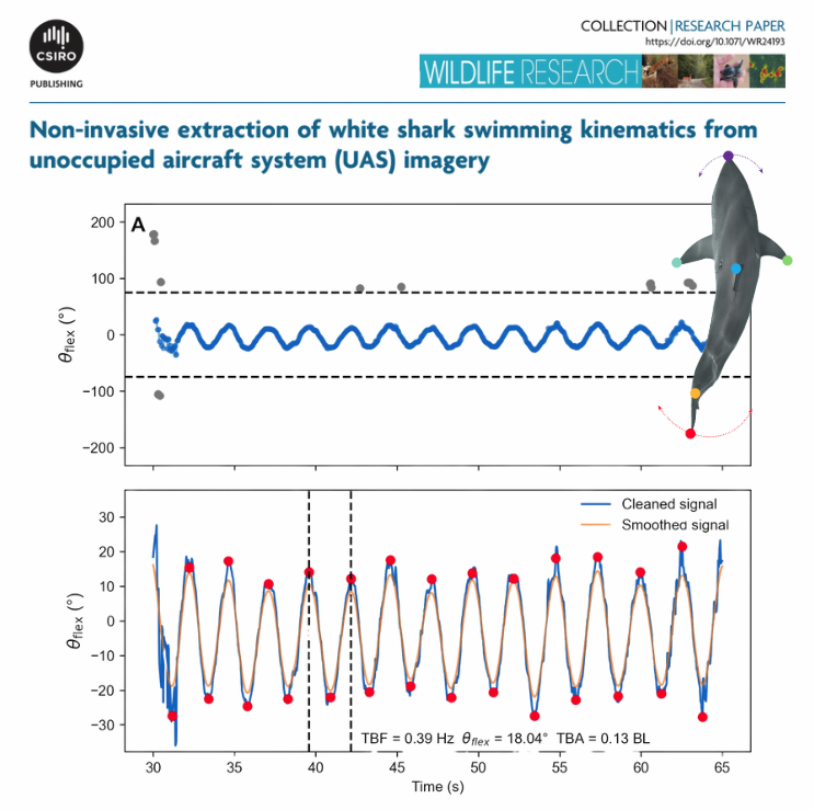
Non-invasive extraction of white shark swimming kinematics from unoccupied aircraft system (UAS) imagery (DiGiacomo et al. 2025)
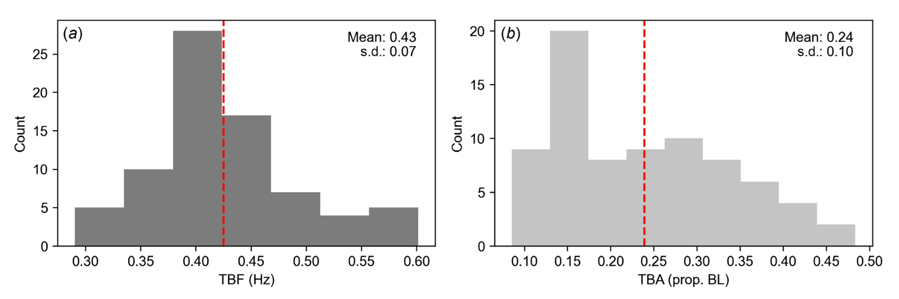
Context: Consumer-grade unoccupied aircraft systems (UAS) are increasingly being used by both scientists and hobbyists in the coastal environment. Marine megafauna are observed via UAS as part of monitoring programs, recreational interests, and scientific research, amassing aerial imagery datasets. Because manual documentation of these datasets is infeasible at scale, efficient approaches leveraging computer vision and deep learning have emerged to detect and classify marine megafauna. Aims: This study provides a workflow to quantitatively estimate swimming kinematics tailbeat frequency (TBF) and tailbeat amplitude (TBA) of white sharks (Carcharodon carcharias) from aerial UAS video data. Methods: Body pose estimation was performed using computer vision model DeepLabCut to track six key white shark body parts across UAS videos. The relative positions of these body part coordinates were used to compute tail position over time and quantify TBF and TBA across a population of white sharks in Monterey Bay, California. Key results: With a training set of just 52 images, the deep residual neural network reaches human-level labeling accuracy of body parts (root mean square error of <1.3 cm). This workflow is applied to 76 focal follows representing 34 individuals to produce TBF (0.43 ± 0.07 Hz) and TBA (0.24 ± 0.10 BL) values similar to those derived from biologging devices previously deployed on individuals in this population. Conclusions: The results indicated that body pose estimation via DeepLabCut can allow for the rapid extraction of quantitative kinematics such as TBF and TBA in juvenile white shark populations that aggregate in coastal habitats. This approach provides a non-invasive, scalable method to understanding megafauna kinematics in sensitive species that overcomes the logistical barriers of traditional biologging approaches.
DOI:10.1071/WR24193
Considerations and tradeoffs of UAS-based coastal wetland monitoring in the Southeastern United States (DiGiacomo et al. 2022)
Coastal wetlands of the Southeastern United States host a high abundance and diversity of critical species and provide essential ecosystem services. A rise in threats to these vulnerable habitats has led to an increased focus on research and monitoring in these areas, which is traditionally performed using manual measurements of vegetative characteristics. As these methods require substantial time and effort, they are often limited in scale and infeasible in areas of dense or impassable habitat. Unoccupied Aircraft Systems (UAS) provide an advantage over traditional ground-based methods by serving as a non-invasive alternative that expands the scale at which we can understand these ecosystems. While recent interest in UAS-based monitoring of coastal wetland habitats has grown, methods and parameters for UAS-based mapping lack standardization. This study addresses variability introduced by common UAS study techniques and forms recommendations for optimal survey designs in vegetated coastal habitats. Applying these parameters, we assess alignment of computed estimations with manually collected measurements by comparing UAS-SfM mapping products to ground-based data. This study demonstrates that, with careful consideration in study design and analysis, there exists great potential for UAS to provide accurate, large-scale estimates of common vegetative characteristics in coastal salt marshes.
https://www.frontiersin.org/articles/10.3389/frsen.2022.924969/full
Elasmobranch Use of Nearshore Estuarine Habitats Responds to Fine-Scale, Intra-Seasonal Environmental Variation: Observing Coastal Shark Density in a Temperate Estuary Utilizing Unoccupied Aircraft Systems (UAS) (DiGiacomo et al. 2020b)
This study provides novel insights into coastal shark population dynamics within the Rachel Carson reserve estuary, a hotspot for shore-based recreational activity in summer months. Understanding the intra-seasonal dynamics of this population is important because the high-abundance season for most shark coastal shark species (summer) coincides with peak shore-based activity for recreational tourism. Understanding and predicting potential conflicts and disruptions to habitat usage within this period is critical for informing potential future conservation efforts. Moreover, this study provides a breakthrough non-invasive, UAS-based methodology for observing shark abundance in temperate estuaries.
https://www.mdpi.com/2504-446X/4/4/74
Modeling Salt Marsh Vegetation Height Using Unoccupied Aircraft Systems and Structure from Motion (DiGiacomo et al. 2020a)
Salt marshes provide important services to coastal ecosystems in the southeastern United States. In many locations, salt marsh habitats are threatened by coastal development and erosion, necessitating large-scale monitoring. Assessing vegetation height across the extent of a marsh can provide a comprehensive analysis of its health, as vegetation height is associated with Above Ground Biomass (AGB) and can be used to track degradation or growth over time. Traditional methods to do this, however, rely on manual measurements of stem heights that can cause harm to the marsh ecosystem. Moreover, manual measurements are limited in scale and are often time and labor intensive. Unoccupied Aircraft Systems (UAS) can provide an alternative to manual measurements and generate continuous results across a large spatial extent in a short period of time. In this study, a multirotor UAS equipped with optical Red Green Blue (RGB) and multispectral sensors was used to survey five salt marshes in Beaufort, North Carolina. Structure-from-Motion (SfM) photogrammetry of the resultant imagery allowed for continuous modeling of the entire marsh ecosystem in a three-dimensional space. From these models, vegetation height was extracted and compared to ground-based manual measurements. Vegetation heights generated from UAS data consistently under-predicted true vegetation height proportionally and a transformation was developed to predict true vegetation height. Vegetation height may be used as a proxy for Above Ground Biomass (AGB) and contribute to blue carbon estimates, which describe the carbon sequestered in marine ecosystems. Employing this transformation, our results indicate that UAS and SfM are capable of producing accurate assessments of salt marsh health via consistent and accurate vegetation height measurements.
https://www.mdpi.com/2072-4292/12/14/2333
Associated Media:


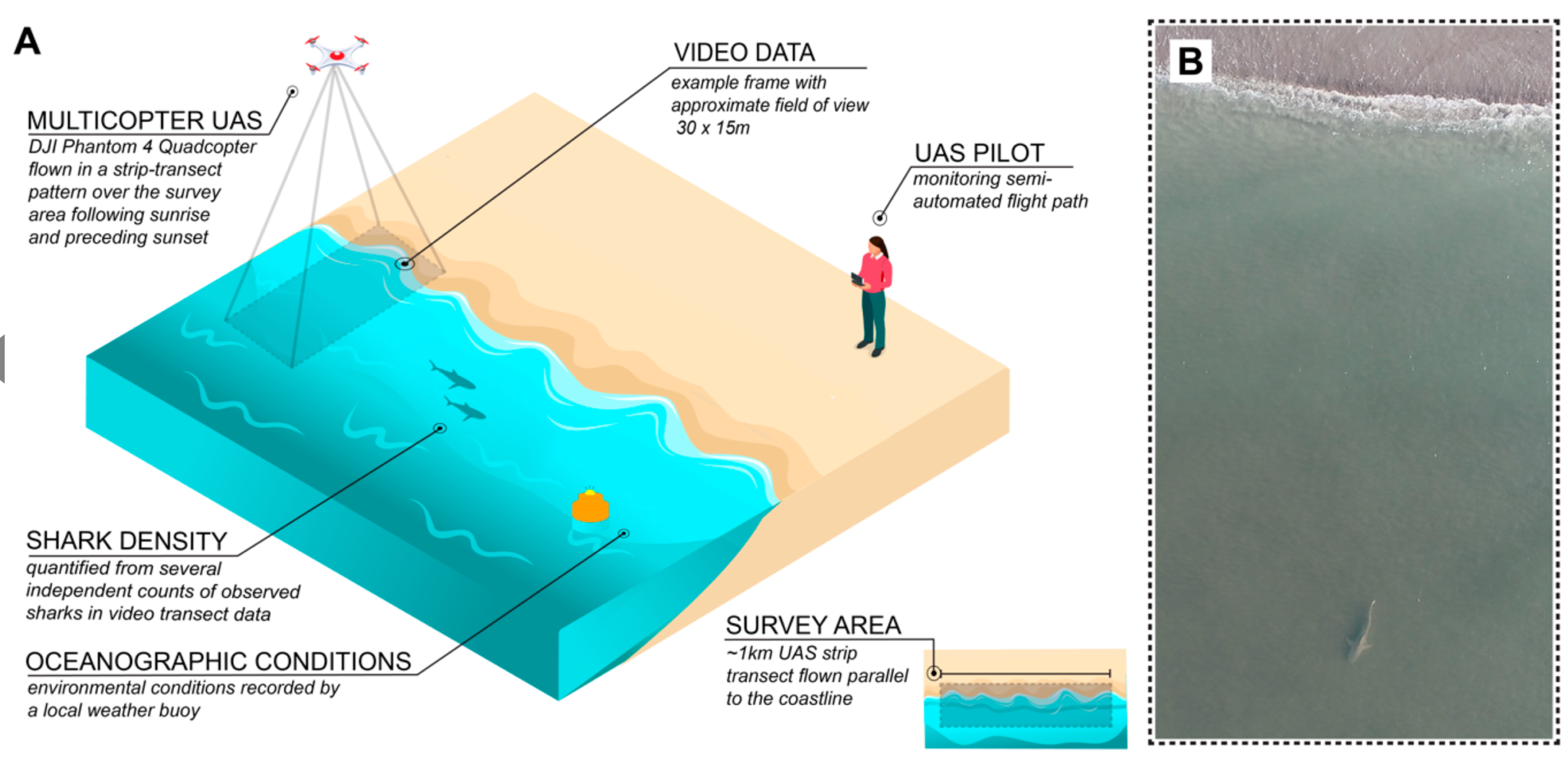
Field operations using Unoccupied Aircraft Systems (UAS) to observe coastal shark density along transects parallel to shore. (A) Study design schematic. (B) True example video frame at Bird Shoal (enlarged for visualization purposes)

Graphical abstract demonstrating image processing workflow deriving vegetation height from aerial imagery.

(a) An example plot is displayed to demonstrate the vertical profile (lateral obstruction) and associated vegetation height predictions across three different DTM generation methods post-transformation. (b) Inverse of the cumulative proportion of grass area encompassed at different stem heights across fifteen sampling quadrats after transformation with corresponding predicted vegetation heights from each of the three methods.